Residents unhappy with council’s decision
By Pam Wright
Local Journalism Initiative Reporter
After decades of inaction, Chatham-Kent is finally moving forward to address ongoing erosion and high-water problems in the flood prone area of Erie Shore Drive.
At a special meeting held at the Bradley Centre Sept. 21, council voted to proceed with a final report on building a new $8.9-million dyke to protect affected land and abandon all groynes and seawalls that are currently part of the Burk Drainage Works.
While some were hesitant in taking the step; many felt the issue had been pushed aside for far too long.
Chatham Coun. Marjorie Crew, who put forward the motion to proceed with the proposal, said approving the fix is “moving forward.
“I think we need to prevent any further risks to the citizens and the agricultural land and Erieau,” Crew said. “Everyone there is at risk if that dyke becomes compromised again. Doing nothing is not the right thing to do. It’s been 100 years this has been kicked down the road. I think we need to invest in this area to make sure we’re not looking at this in 15 or 20 years.”
Chatham Coun. Michael Bondy said council should not delay in addressing the problem.
“I’ve been sitting here for a long time and we’ve been talking about this for a long time,” Bondy said. “People before me were talking about for a long time as well, so here we are. I’m not comfortable not repairing it.”
According to the engineering report, there are around 726 hectares of land within the Burk system, including 75 agricultural properties, roads and McGeachy’s Pond. The area is served by a series of dykes and a number of internal gravity systems with a mechanically pumped outlet into Lake Erie. There are 153 year-round and seasonal residential properties located along the lakeshore.
The fix, as recommended by administration, includes relocating the Lakeshore Drain and building a new dyke on the north side of the road to prevent flows from the lake overtopping the dyke system. According to an engineering report, it provides increased flood protections for the land, minimizes the duration of flooding and provides front yard drainage for the residents of Erie Shore Drive.
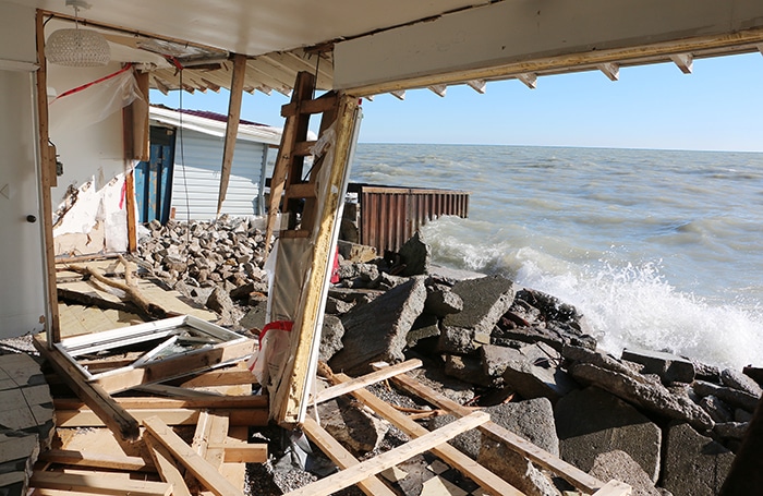
Erie Shore Drive has been affected by rough waves and high-water levels periodically for many years, and the issue has been extensively studied in the past. In March 2020, the threat of flooding forced many residents from their homes with the municipality declaring a state of emergency, closing the road for a period in the spring.
The municipality also undertook expensive mitigation measures, such as installing large concrete blocks, to try and protect the road and shore.
In 2021, some 80 members of the Erie Shore Drive Property Owner’s Association launched a lawsuit against Chatham-Kent, seeking damages related to high-water problems.
The matter is still before the courts. Dave Taylor, director of legal services for C-K, said a decision from the drainage referee could take anywhere from a year to 18 months or longer.
Council heard one verbal deputation and received one e-mail message on the matter. Terra Cadeau, president of the Erie Shore Property Owner’s Association, asked council to consider postponing any action as there is a currently the legal matter before the provincial drainage referee.
In her comments, Cadeau told council that the groyne and seawall system currently in place works well and is paid for and maintained entirely by lakefront property owners.
She said Chatham-Kent has been negligent in protecting the groynes and dykes that are part of the Burk system.
The actions taken by council instruct the completion of a preliminary report only and final details may still be changed.
A motion put forward by South Kent Coun. Ryan Doyle to postpone taking action was defeated.
Following the meeting, Cadeau told reporters she was disappointed with council’s decision, saying it abandons property owners on the south side of the road.
Other proposals from past engineering studies were also considered. Further protections, including adding a reservoir and second pump, can be added to the current proposal for the additional cost of just under $1 million.
The new improvements do not require a petition under the Drainage Act and can proceed under the authority of council.
Two other very expensive plans were also presented. One, with a price tag of $61 million, would have seen rock and groyne features installed on the lakebed to promote beach formation along the shore.
Another, as recommended in the Zuzek Report, would have included armour rock revetment installed along the shoreline at a cost of more than $83 million.
But the new plan will cost as well. The estimated assessment on agricultural land is $3,500 an acre, equalling $350,000 for a 100-acre farm. However, agricultural property owners will be eligible to apply for a grant from the Ontario Ministry of Agriculture and Food for a one-third grant to cover costs.
The average assessment on lakefront properties is estimated at $5,180.
Under the current proposal, the road would be left as is.
Council also approved lobbying higher levels of government for funding to assist with the endeavour, following a recommendation from South Kent Coun. Anthony Ceccacci.


