By Pam Wright
Local Journalism Initiative Reporter
Chatham-Kent’s future plan to reroute traffic away from Lake Erie by cutting through farmland and building a new 30-kilometre stretch of road is being met with stiff opposition.
A citizen’s group comprised of affected property owners and farmers has collected close to 600 signatures on a petition protesting the proposal.
“Save Our Farms, Save Our Shoreline, Save Our Forests and Wildlife, and Save Talbot Trail” is the motto of the grassroots group that came together after proposed changes were endorsed by council in July.
According to co-organizer John Mann, members of the group have knocked on the doors of every affected resident in the area and their efforts are gathering steam. At a meeting the group held in late September at the Merlin Legion, some 170 concerned citizens packed the building to capacity.
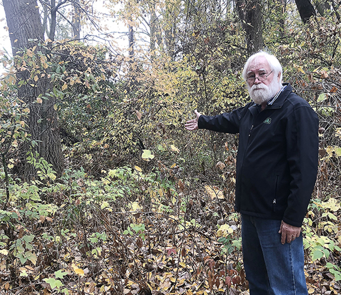
Mann, a retired Chrysler engineer, is one of the landowners on Talbot Trail that would be affected. If it’s ever built, the proposed road will slice through his 100-acre farm near Dealtown and he’s not happy about it.
In addition to cash crops, Mann and his wife Maria, have a mature woodlot he said is part of a wildlife corridor.
“The road will go right through this,” he said, as he pointed out an animal pathway in the woods.
Mann said a lot of landowners believe Chatham-Kent has not fully explored the issue and endorsed recommendations from an environment assessment study that didn’t include full consultation with landowners.
The committee is calling the municipality’s public engagement process into question. Mann said community consultation on the matter undertaken during the pandemic – was mainly online and most residents were unaware.
However, a in-person Community Cafe was held at the Tilbury Arena in February 2020. Two virtual public information centre meetings on Nov. 30, 2021 and on April 22, 2022 were also held.
Mann said most residents were unaware the sessions were taking place or couldn’t access them.
“What farmer or person out here even has the Internet capacity to be able to attend those meetings?” Mann asked during an interview with The Voice. “I certainly don’t have that much Internet capacity.”
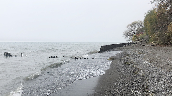
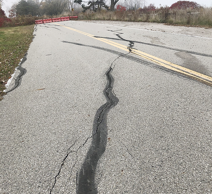
In 2019, Chatham-Kent council decided to close a portion of Talbot Trail near Coatsworth Road, as the highway’s integrity was threatened by erosion. Following the closure, Chatham-Kent hired BT Engineering to conduct an environmental assessment study to scope out the problem and come up with solutions.
A recommendation to build a $1-billion armoured stone wall along the shoreline got a thumbs down from administration. Instead, the municipality has recommended permanently diverting Talbot Trail around the closed portion near Coatsworth, which while there is not set date, would be undertaken in the near future. Council also formally endorsed the second phase of the project to be completed as needed, when erosion worsens and funding becomes available, but no final approvals are set.
Chatham-Kent council endorsed the two-phase plan in July 2022 in response to current and future erosion along the Lake Erie shore.
Phase One of the project has two parts. The first would see Talbot Trail rerouted north along Coatsworth Road to the Concession Line 2 before heading east to Stevenson Road and south to Talbot Trail.
The second part would extend the detour by moving Talbot Trail north, from Ellerbeck Road near Wheatley to Stevenson Road. Phase Two would move Talbot Trail north through farms and forests from Stevenson Road all the way to Craford Road near Cedar Springs.
However at the Sept. 11 meeting, council opted to split the Talbot Trail engineering assessment into two separate submissions. According to Mark McFadden, Chatham-Kent’s manager of engineering for traffic and underground infrastructure, the environmental study report for the first phase has yet to be finalized. The next step is a 60-day day public review period to be implemented by council.
Regarding the second phase, council has directed administration to prepare a report that will include costs associated with the review, revaluation and the finalization of the ESR that includes community input.
Council also provided further clarification the project would be put on hold until administration returned with a report on associated costs.
“As such, the 60-day public review period has not been initiated for either Part A or Part B,” McFadden said.
Regardless, Mann believes an important piece has been left out of the decision-making process regarding Talbot Trail and that’s the experience of those who live along the lake.
“If you do something, the lake doesn’t erode,” Mann stated, noting people have mitigated erosion for years, typically by building groynes and adding concrete or stones.
“We need to tap into the experience of people whose families have lived here for 100 years,” he stressed.
Other erosion control methods include grading the slope, putting in barriers, adding vertical culverts (for wave impact) and revetment walls, Mann explained.
He acknowledges that some of the measures are expensive but noted that expropriating land to build a highway is also costly, adding folks with lakefront property could get special tax breaks and other incentives for erosion control.
“It’s a no brainer,” Mann said. “There are all kinds of other places in the world that have this problem, we are not alone.
“We should not be trying to solve this problem by using solutions that we’ve used in the past. We should be using global solutions looking for best practices across the world.”
According to Mann, there are four spots along Talbot Trail that need immediate attention but beyond that, the road remains safe. He said that opinion was reached after consulting with property owers.
The citizen group also does not support permanently closing Talbot Trail at Coatsworth and said it should be fixed and reopened.
“You don’t even need to move the highway,” said Mann. “The highway is just fine where it is.”
Mann said the recommendations of the environmental assessment are based on a study by engineering firm Zuzek Inc. hired to probe the erosion issue and find solutions.
Formerly a provincial highway, the responsibility for Talbot Trail was downloaded onto Chatham-Kent in the 1990s. In 2010, Chatham-Kent had to build a $200,000 bypass in the Coatsworth area after bank erosion caused a major crack in the highway.
The Talbot Trail erosion issue will be one of the first agenda items the new council has to deal with. Mann said the group plans to attend council and present the petition in person.


well I guess if Chatham-Kent want to expropriate property they have to reimburse the farmer the value. Now in the case of these farmers property could be sold for GreenHouse operations for what $40-50,000 an acre is Chatham-kent prepared to pay that? As a Chatham-Kent Tax payer living on the lake for 40+ year and have not lost 6″ yes six inches of property to the lake. Yes i paid for a breakwall and jetties also graded the bank down to (I think) 40% sloop. But it worked and I have advised Council if this when the issue came up in 2019.
I am keen to communicate with John Mann. Can you please provide me with his email address or if that’s not possible, please pass on my email address and ask him to contact me. Many thanks.