By John Rhodes
Special to The Chatham Voice
My Chatham Voice editor, Bruce Corcoran, recently received a note from a reader wishing to confirm that his home, on Algonquian Drive, stands close to the spot where the pro shop of the old Chatham Golf Club once stood.
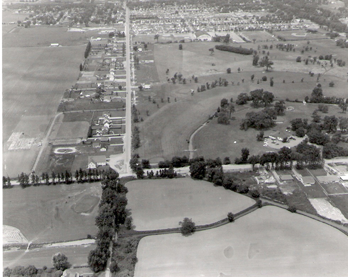
I compared his street number with a current map and an aerial photo, from the 1950s, and the estimation is reasonably accurate.
The golf course was created in 1919 on a tract of land bounded by Lacroix Street, Indian Creek Road West, Queen Street, and the New Athletic Grounds which currently accommodates Fergie Jenkins Field, Memorial Arena, etc.
The Old Athletic grounds were bounded by Queen Street, Deluth Street and William Street but were exposed to private development in 1905.
The aerial photo I have included faces north, with Indian Creek Road West running horizontally, across the bottom, and Lacroix Street running vertically to the left of centre.
Originally known as the Elmwood Golf Club, it was built on pasture land prone to flooding.
Many years ago I had the privilege of interviewing the late William McKenzie Ross III, who lived to be 100 years old, regarding the property and he told me that the land was used for pasture as it was too low and prone to flooding for development.
Originally, the golf course functioned well as a nine-hole format but after the Second World War, the mode was to expand to 18-hole operations and the Chatham club followed that pattern in the mid 1950s when it expanded, kiddy corner, to my grandfather’s farm at the southwest corner of Indian Creek Road West and Lacroix Street.
The course functioned well until the late 1950s when the decision was made to sell the property and move the operation to a new location in Harwich township where the course would be called the Maple City Golf and Country Club.
One unique factor concerning the Elmwood golf course was the premise that the holes had names; 1 was Bridge, 3 was Boulevard, 4 was Elms, 5 was Shady lane, 6 was Elbow, 7 was Lacroix, 8 was Faraway, and 9 was Home. I was not able to learn the name of hole 2.
In the late 50s, the property was sold and the members built a new course in Chatham Township. There was an odd situation regarding the dispense of alcohol which required the club house to be in Chatham Township while the course was across the river in Harwich township, the two entities connected by an odd looking barrel-supported bridge.
I should point out one oddity about the photo: The scape, in the lower right corner, appears to be water, when it is actually wheat, ready for harvest in early July of that year.